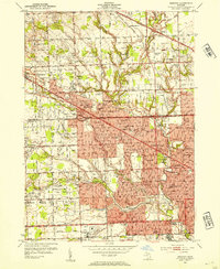
1952 Map of Redford
USGS Topo · Published 1954About this map
Livonia and the western reaches of Detroit are captured during a period of rapid mid-century suburbanization, where former agricultural tracts are being transformed into residential grids. The landscape is defined by its major arterial roads, including Grand River Ave and the developing Northwestern Highway, which facilitate the growth of communities like Clarenceville and Grand River Oaks. The area is notably dense with institutional and social infrastructure, featuring numerous parochial and public schools such as St Agatha Sch and Bentley High Sch. Large-scale land uses are prominent, including the extensive Holy Sepulchre Cemetery and the Detroit Race Course near the Chesapeake and Ohio rail line. The Bell Branch of the Rouge River meanders through the southeast, providing a natural corridor for green spaces like Eliza Howell Park amidst the burgeoning urban sprawl.
Find a feature on this map
97 named features on this map. Tap any name to fly to it.
Don’t see what you’re looking for? This feature index may not catch every label — zoom into the map to look around manually.
Map Details
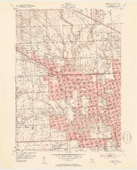
Editions of this 1952 Redford Map
2 editions found
Other maps of this area

1905 · Wayne
USGS Topo · 1:62,500

1905 · Detroit
USGS Topo · 1:62,500

1907 · Pontiac
USGS Topo · 1:62,500

1908 · Rochester
USGS Topo · 1:62,500

1912 · Wayne
USGS Topo · 1:62,500

1918 · Detroit
USGS Topo · 1:62,500

1924 · Detroit
USGS Topo · 1:62,500

1934 · Detroit
USGS Topo · 1:62,500

1936 · Inkster
USGS Topo · 1:31,680

1936 · Wayne
USGS Topo · 1:31,680