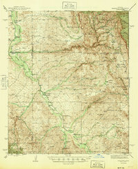
1945 Map of Redington
USGS Topo · Published 1945About this map
The San Pedro River valley serves as the primary corridor for settlement in this part of Arizona during the early 1940s, with a series of family-named ranches following the water's edge. Communities like Redington and Cascabel anchor a landscape defined by cattle ranching and intermittent mining, where local infrastructure such as the Pool Sch and the Tucson Rd provided essential connections for residents. While the valley floor is populated by active sites like Bingham Ranch and CarLink Ranch, the map also records the desert's shifts, specifically noting the Soza Ranch (abandoned). To the east and west, the terrain rises sharply into the Crook National Forest and Coronado National Forest, where high-elevation landmarks like Wildcat Peak and the Jackson Mine suggest a more industrial and wild character far above the riverbanks.
Find a feature on this map
63 named features on this map. Tap any name to fly to it.
Don’t see what you’re looking for? This feature index may not catch every label — zoom into the map to look around manually.
Map Details
Editions of this 1945 Redington Map
2 editions found

Other maps of this area

1904 · Tucson
USGS Topo · 1:125,000

1905 · Tucson
USGS Topo · 1:125,000

1911 · Winkelman
USGS Topo · 1:125,000

1913 · Winkelman
USGS Topo · 1:125,000

1938 · Galiuro Mts
USGS Topo · 1:48,000

1940 · Sierra Bonita Ranch
USGS Topo · 1:62,500

1942 · Sierra Bonita Ranch
USGS Topo · 1:62,500

1943 · Galiuro Mts
USGS Topo · 1:62,500

1943 · Dragoon
USGS Topo · 1:62,500

1943 · Sierra Bonita Ranch
USGS Topo · 1:62,500