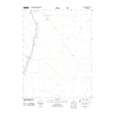
2011 Map of Redstone
USGS Topo · Published 2011About this map
The Redstone settlement and the winding corridor of the Crystal River anchor this 2011 survey of the Colorado Rockies. This area is characterized by deep drainage basins and significant elevation changes, with numerous tributaries such as Hell Roaring Creek and Avalanche Creek feeding into the main river valley. Evidence of the region’s industrial and recreational history is clear, from the Ground Hog Group Mine tucked into the slopes to the clustering of sites like the Osgood Campground and Penny Hot Springs. The map documents a landscape defined by its rugged topography, where human activity is concentrated along narrow valley floors and historical routes like Redstone Blvd. Higher elevations like Dooly Park remain largely undeveloped, highlighting the stark contrast between the settled riverfront and the surrounding mountain wilderness.
Find a feature on this map
25 named features on this map. Tap any name to fly to it.
Don’t see what you’re looking for? This feature index may not catch every label — zoom into the map to look around manually.
Map Details
Editions of this 2011 Redstone Map
This is the sole edition of this map. No revisions or reprints were ever made.
Other maps of this area

1957 · Leadville
USGS Topo · 1:250,000

1959 · Leadville
USGS Topo · 1:250,000

1960 · Leadville
USGS Topo · 1:250,000

1960 · Marble
USGS Topo · 1:24,000

1960 · Capitol Peak
USGS Topo · 1:24,000

1960 · Redstone
USGS Topo · 1:24,000
1960 · Snowmass Mountain
USGS Topo · 1:24,000

1961 · Mount Sopris
USGS Topo · 1:24,000

1961 · Basalt
USGS Topo · 1:24,000

1962 · Leadville
USGS Topo · 1:250,000