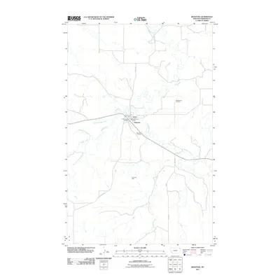
2011 Map of Redstone
USGS Topo · Published 2011About this map
Redstone serves as the focal point of this Sheridan County landscape, where the confluence of several waterways defines the local geography. The settlement is anchored by agricultural and civic infrastructure, notably the Redstone Grain Company and the Redstone Post Office. The surrounding terrain is deeply carved by Big Muddy Creek and its tributaries, including Eagle Creek and the North Fork Eagle Creek. This drainage network suggests a landscape shaped by seasonal water flow, further evidenced by the presence of the Primrose Dam to the south. For those tracing local heritage, the map identifies two distinct burial sites: Valleyview Cemetery near the town center and the Old Redstone Cemetery located to the northeast. The distribution of these sites and the named roads like Bergh Rd and Daleview Rd reflect the enduring rural layout of this northeastern Montana community.
Find a feature on this map
17 named features on this map. Tap any name to fly to it.
Don’t see what you’re looking for? This feature index may not catch every label — zoom into the map to look around manually.
Map Details
Editions of this 2011 Redstone Map
This is the sole edition of this map. No revisions or reprints were ever made.
Other maps of this area

1954 · Wolf Point
USGS Topo · 1:250,000

1958 · Wolf Point
USGS Topo · 1:250,000

1973 · Navajo
USGS Topo · 1:24,000

1973 · Goodale Coulee
USGS Topo · 1:24,000

1973 · Pleasant Prairie NE
USGS Topo · 1:24,000
1983 · Daleview
USGS Topo · 1:24,000

1983 · Outlook
USGS Topo · 1:24,000

1983 · Redstone
USGS Topo · 1:24,000

1983 · Soo NW
USGS Topo · 1:24,000

1983 · Archer
USGS Topo · 1:24,000