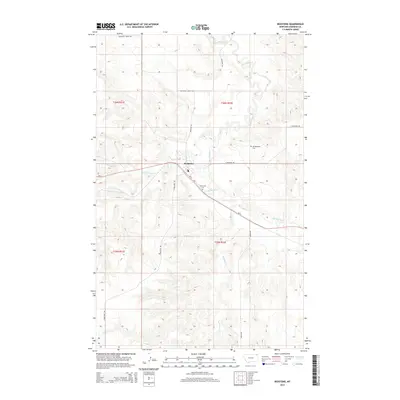
2014 Map of Redstone
USGS Topo · Published 2014About this map
Redstone serves as the focal point for this section of Sheridan County, situated where MT-5 intersects with the local road network. The landscape is defined by the winding course of Big Muddy Cr, which draws several tributaries across the terrain, including Redstone Cr and the various branches of Eagle Creek. For family historians, the presence of both the Old Redstone Cem and Valleyview Cem provides specific points of interest for tracing local heritage. The map documents a predominantly rural environment organized by the Public Land Survey System, with section lines and gravel roads such as Daleview Rd and Whitetail Creek Rd cutting through the prairie. This arrangement reflects the enduring agricultural structure of northeast Montana, where small settlements and rural cemeteries mark the locations of early homesteads along the creek valleys.
Find a feature on this map
18 named features on this map. Tap any name to fly to it.
Don’t see what you’re looking for? This feature index may not catch every label — zoom into the map to look around manually.
Map Details
Editions of this 2014 Redstone Map
This is the sole edition of this map. No revisions or reprints were ever made.
Other maps of this area

1954 · Wolf Point
USGS Topo · 1:250,000

1958 · Wolf Point
USGS Topo · 1:250,000

1973 · Navajo
USGS Topo · 1:24,000

1973 · Goodale Coulee
USGS Topo · 1:24,000

1973 · Pleasant Prairie NE
USGS Topo · 1:24,000
1983 · Daleview
USGS Topo · 1:24,000

1983 · Outlook
USGS Topo · 1:24,000

1983 · Redstone
USGS Topo · 1:24,000

1983 · Soo NW
USGS Topo · 1:24,000

1983 · Archer
USGS Topo · 1:24,000