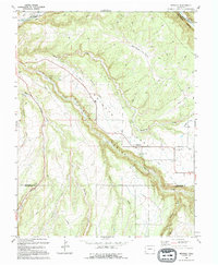
1994 Map of Redvale
USGS Topo · Published 1994About this map
Wrights Mesa forms a distinct agricultural plateau in western Colorado, where irrigation infrastructure like the Lilylands Canal (North Lateral), Gurley Ditch, and Browning Ditch supported high-altitude farming. This map shows the small settlements of Redvale and Coventry positioned along the canyon rims, surrounded by a complex network of draws and canyons including Naturita Canyon and Hamilton Broad Canyon.
Find a feature on this map
30 named features on this map. Tap any name to fly to it.
Don’t see what you’re looking for? This feature index may not catch every label — zoom into the map to look around manually.
Map Details
Editions of this 1994 Redvale Map
This is the sole edition of this map. No revisions or reprints were ever made.
Other maps of this area

1916 · Paradox Valley
USGS Topo · 1:125,000

1922 · Paradox Valley
USGS Topo · 1:125,000

1956 · Moab
USGS Topo · 1:250,000

1959 · Moab
USGS Topo · 1:250,000

1960 · Moab
USGS Topo · 1:250,000
1960 · Nucla
USGS Topo · 1:24,000
1960 · Nucla
USGS Topo · 1:62,500

1962 · Moab
USGS Topo · 1:250,000

1964 · Moab
USGS Topo · 1:250,000
1964 · Basin
USGS Topo · 1:24,000