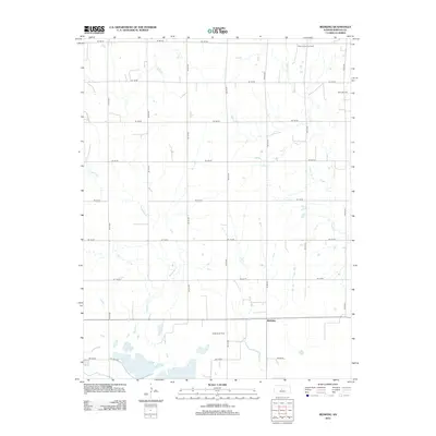
2012 Map of Redwing
USGS Topo · Published 2012About this map
Redwing stands at the heart of this Barton County landscape, serving as a focal point in a region defined by agricultural grid lines and petroleum extraction. The map documents an area where heavy industry and rural life intersect, shown through the sprawling extents of the Beaver South Oil Field and the Odin Oil Field. These energy-producing zones surround the primary settlement, while the Redwing Oil Field is situated directly to its west. The natural drainage of the land is shaped by the winding paths of Deception Cr and Cow Cr, which cut through the strictly rectilinear road network composed of avenues and roads like NE 50 Ave and NE 130 Rd. This 2012 survey illustrates the modern footprint of Kansas oil production in a traditional plains setting.
Find a feature on this map
21 named features on this map. Tap any name to fly to it.
Don’t see what you’re looking for? This feature index may not catch every label — zoom into the map to look around manually.
Map Details
Editions of this 2012 Redwing Map
This is the sole edition of this map. No revisions or reprints were ever made.
Other maps of this area

1891 · Great Bend
USGS Topo · 1:125,000

1893 · Great Bend
USGS Topo · 1:125,000

1896 · Russell
USGS Topo · 1:125,000

1955 · Great Bend
USGS Topo · 1:250,000

1956 · Ellinwood NE
USGS Topo · 1:24,000

1956 · Ellinwood NW
USGS Topo · 1:24,000

1957 · Great Bend
USGS Topo · 1:250,000

1958 · Great Bend
USGS Topo · 1:250,000

1959 · Great Bend NE
USGS Topo · 1:24,000
1969 · Claflin
USGS Topo · 1:24,000