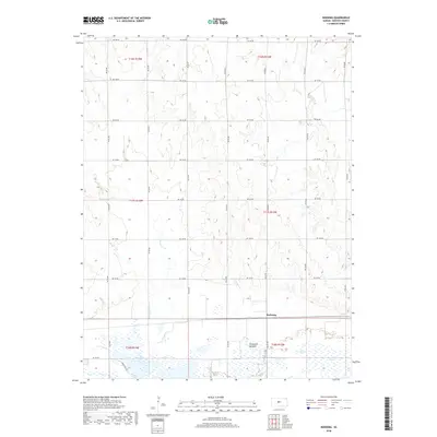
2018 Map of Redwing
USGS Topo · Published 2018About this map
Cheyenne Bottoms dominates the southern reaches of this landscape, a significant wetland basin that includes Pool 3B and various smaller marshes. This ecological feature forms a sharp contrast to the organized agricultural grid to the north, where section lines are defined by a network of rural roads such as NE 180 Rd and NE 20 Ave. The small settlement of Redwing serves as a local focal point, situated just above the northern edge of the marshlands and linked to the surrounding territory by the regional road system. Drainage across the northern plains is provided by meandering seasonal waterways, including Deception Cr and Cow Cr, which trace through the high ground before descending toward the basin. The map illustrates a classic Central Kansas pattern of wide-open agricultural land-use directly bordering one of the state's most important natural hydrologic systems.
Find a feature on this map
27 named features on this map. Tap any name to fly to it.
Don’t see what you’re looking for? This feature index may not catch every label — zoom into the map to look around manually.
Map Details
Editions of this 2018 Redwing Map
This is the sole edition of this map. No revisions or reprints were ever made.
Other maps of this area

1891 · Great Bend
USGS Topo · 1:125,000

1893 · Great Bend
USGS Topo · 1:125,000

1896 · Russell
USGS Topo · 1:125,000

1955 · Great Bend
USGS Topo · 1:250,000

1956 · Ellinwood NE
USGS Topo · 1:24,000

1956 · Ellinwood NW
USGS Topo · 1:24,000

1957 · Great Bend
USGS Topo · 1:250,000

1958 · Great Bend
USGS Topo · 1:250,000

1959 · Great Bend NE
USGS Topo · 1:24,000
1969 · Claflin
USGS Topo · 1:24,000