2023 Map of Redwood
USGS Topo · Published 2023About this map
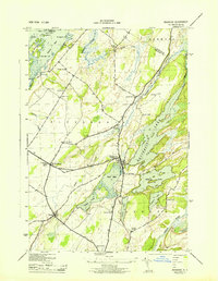
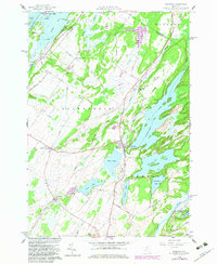
The village of Redwood sits at the heart of a glacial landscape defined by an intricate network of narrow lakes and limestone ridges in Jefferson County. This contemporary study shows the settlement's relationship with Butterfield Lake and Mud Lake, while the smaller community of Plessis anchors the southwestern portion of the map. For genealogists, the map identifies several local burial grounds including Redwood Cem, Barnes Cem, and Hill Cem, which are scattered among family-named roads like Hunnyman Rd and Dorr Rd. The topography is dominated by water, from the complex shoreline of Goose Bay featuring islands like Portage Island and Caprice Island, to the inland waters of Millsite Lake and Sixberry Lake. The Indian River cuts through the southeastern corner, serving as a primary drainage for the countless wetlands and creeks that define this portion of the Thousand Lakes region.
Find a feature on this map
90 named features on this map. Tap any name to fly to it.
Don’t see what you’re looking for? This feature index may not catch every label — zoom into the map to look around manually.
Map Details
Editions of this 2023 Redwood Map
This is the sole edition of this map. No revisions or reprints were ever made.
Historical Maps of Goose Bay Through Time
3 maps found