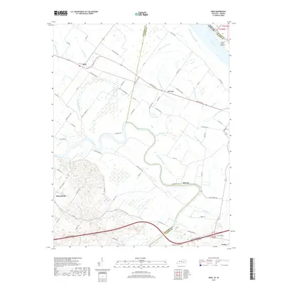
2019 Map of Reed
USGS Topo · Published 2019About this map
The Green River meanders through this portion of Henderson and Daviess Counties, defining a landscape of wetlands and managed drainage systems just south of the Ohio River. Small rural settlements like Reed, Newman, and Birk City anchor the region's road network, which is dominated by long routes such as Reed Owensboro Rd and Bluff City-Newman Rd. The topography is marked by numerous sloughs and ditches, including Richland Slough and Hurricane Slough, illustrating the perennial efforts to manage the low-lying terrain near the river junctions.
Find a feature on this map
70 named features on this map. Tap any name to fly to it.
Don’t see what you’re looking for? This feature index may not catch every label — zoom into the map to look around manually.
Map Details
Editions of this 2019 Reed Map
This is the sole edition of this map. No revisions or reprints were ever made.
Other maps of this area

1901 · Owensboro
USGS Topo · 1:62,500

1905 · Newburg
USGS Topo · 1:62,500

1906 · Sutherland
USGS Topo · 1:62,500

1908 · Calhoun
USGS Topo · 1:62,500

1951 · Yankeetown
USGS Topo · 1:24,000

1951 · Spottsville
USGS Topo · 1:24,000

1952 · Owensboro West
USGS Topo · 1:24,000

1952 · Newburgh
USGS Topo · 1:24,000

1952 · Reed
USGS Topo · 1:24,000
1953 · Delaware
USGS Topo · 1:24,000