
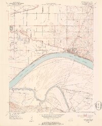
1952 Map of Newburgh
USGS Topo · Published 1953About this map
Angel Mounds State Memorial and the riverfront town of Newburgh anchor this early 1950s survey of the riverbanks where Indiana meets Kentucky. The landscape is defined by the sweeping curves of the Ohio River and its confluence with the Green River, a region dominated by intricate drainage systems including Nurenbern Ditch and Edwards Ditch.
Find a feature on this map
41 named features on this map. Tap any name to fly to it.
Don’t see what you’re looking for? This feature index may not catch every label — zoom into the map to look around manually.
Map Details
Editions of this 1952 Newburgh Map
2 editions found
Other maps of this area

1901 · Haubstadt
USGS Topo · 1:62,500

1902 · Ditney
USGS Topo · 1:125,000

1902 · Boonville
USGS Topo · 1:62,500

1903 · Haubstadt
USGS Topo · 1:62,500

1903 · Patoka
USGS Topo · 1:125,000

1905 · Newburg
USGS Topo · 1:62,500

1914 · Henderson
USGS Topo · 1:48,000

1916 · Henderson
USGS Topo · 1:62,500

1951 · Yankeetown
USGS Topo · 1:24,000

1951 · Spottsville
USGS Topo · 1:24,000