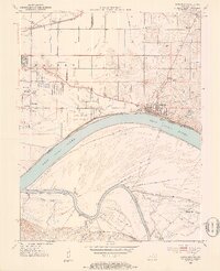
1952 Map of Newburgh
USGS Topo · Published 1953About this map
Angel Mounds State Memorial and the riverfront town of Newburgh anchor this mid-century survey at the sharp bend of the Ohio River. The landscape reveals a complex network of wetlands and seasonal drainages, including Deadman Drain, Griffith Slough, and Cypress Slough, which define the low-lying bottoms across the state line in Kentucky. Transportation is dominated by the Southern and Louisville and Nashville railroads, while the river economy is represented by Lock No 47 and the prominent Threemile Island. Local genealogical details are abundant, featuring small rural communities like Smythe and Paradise, along with numerous family burial grounds such as Hedge Cem, Casey Cem, and Brickwall Cem. The presence of the Radio Towers (WGBF) and several scattered schoolhouses like Caze Sch illustrates the post-war infrastructure and community life of the Knight and Ohio townships.
Find a feature on this map
47 named features on this map. Tap any name to fly to it.
Don’t see what you’re looking for? This feature index may not catch every label — zoom into the map to look around manually.
Map Details
Editions of this 1952 Newburgh Map
2 editions found

Other maps of this area

1901 · Haubstadt
USGS Topo · 1:62,500

1902 · Ditney
USGS Topo · 1:125,000

1902 · Boonville
USGS Topo · 1:62,500

1903 · Haubstadt
USGS Topo · 1:62,500

1903 · Patoka
USGS Topo · 1:125,000

1905 · Newburg
USGS Topo · 1:62,500

1914 · Henderson
USGS Topo · 1:48,000

1916 · Henderson
USGS Topo · 1:62,500

1951 · Yankeetown
USGS Topo · 1:24,000

1951 · Spottsville
USGS Topo · 1:24,000