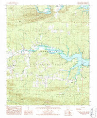
1986 Map of Reed Mountain
USGS Topo · Published 1986About this map
Ouachita National Forest blankets the ridges and valleys of Montgomery County in this mid-1980s provisional study. The landscape is defined by the expansive Lake Ouachita and the winding Ouachita River, which feeds into the reservoir. Near the western edge, the town of Mount Ida serves as a local hub, supported by the Mount Ida Muni Airport and a network of creeks including Williams Creek and Rogers Creek. Evidence of local industry and quiet history appears in the Crystal Mine on Gardner Mountain and the solitary Lone Grave Cem in the northwest. Small settlements like Sweethome, Silver, and Rubie are connected by unimproved roads and a Trail system that traverses Reed Mountain and Wolfe Mountain. The map captures a moment when recreation at Buddys Landing coexisted with rural timber and mining interests.
Find a feature on this map
24 named features on this map. Tap any name to fly to it.
Don’t see what you’re looking for? This feature index may not catch every label — zoom into the map to look around manually.
Map Details
Editions of this 1986 Reed Mountain Map
This is the sole edition of this map. No revisions or reprints were ever made.
Other maps of this area

1890 · Mount Ida
USGS Topo · 1:125,000

1890 · Hot Springs
USGS Topo · 1:125,000

1894 · Hot Springs
USGS Topo · 1:125,000

1906 · Caddo Gap
USGS Topo · 1:125,000

1936 · Glenwood
USGS Topo · 1:48,000

1942 · Glenwood
USGS Topo · 1:62,500

1949 · Glenwood
USGS Topo · 1:62,500

1955 · Little Rock
USGS Topo · 1:250,000

1956 · Little Rock
USGS Topo · 1:250,000

1959 · Mount Ida
USGS Topo · 1:62,500