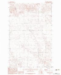
1983 Map of Reed Springs
USGS Topo · Published 1983About this map
Reed Springs serves as the focal point for this high-plains landscape in Roosevelt County, mapped here as it appeared in the early 1980s. The terrain is defined by the drainage patterns of Boxelder Creek, which cuts through the central portion of the quadrangle, and the North Fork Tule Creek to the south. Notable elevation markers like Castle Rock provide navigational orientation in an area otherwise characterized by systematic section lines and small-scale land use, such as a localized Gravel Pit. The map captures the quiet ranching and open-range character of the Fort Peck Indian Reservation during this era, illustrating the sparse but deliberate placement of homesteads and water sources necessary for life in this part of Montana.
Find a feature on this map
8 named features on this map. Tap any name to fly to it.
Don’t see what you’re looking for? This feature index may not catch every label — zoom into the map to look around manually.
Map Details
Editions of this 1983 Reed Springs Map
This is the sole edition of this map. No revisions or reprints were ever made.
Other maps of this area

1910 · Cuskers
USGS Topo · 1:62,500

1915 · Tule Valley
USGS Topo · 1:62,500

1915 · Cuskers
USGS Topo · 1:62,500

1954 · Wolf Point
USGS Topo · 1:250,000

1958 · Wolf Point
USGS Topo · 1:250,000

1973 · Nielsen Coulee
USGS Topo · 1:24,000

1973 · Peerless 4 SE
USGS Topo · 1:24,000

1973 · Peerless 4 SW
USGS Topo · 1:24,000
1983 · Tule Valley East
USGS Topo · 1:24,000
1983 · Tule Valley West
USGS Topo · 1:24,000