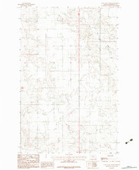
1983 Map of Tule Valley West
USGS Topo · Published 1983About this map
Tule Valley in Roosevelt County, Montana, is defined by the drainage patterns of Tule Creek and its tributary, the West Fork Tule Creek. This 1983 provisional survey documents a landscape primarily shaped by the winding watercourses and the agricultural or ranching land within the r46e r47e and t30n t29n townships. While largely an open valley landscape, the map identifies specific points of human activity and utility, such as a Gravel Pit and a local Cem. The absence of large town centers emphasizes the rural, dispersed nature of the settlements and infrastructure in this part of northeastern Montana during the late twentieth century.
Find a feature on this map
7 named features on this map. Tap any name to fly to it.
Don’t see what you’re looking for? This feature index may not catch every label — zoom into the map to look around manually.
Map Details
Editions of this 1983 Tule Valley West Map
This is the sole edition of this map. No revisions or reprints were ever made.
Other maps of this area

1910 · Todd Lakes
USGS Topo · 1:62,500

1915 · Tule Valley
USGS Topo · 1:62,500

1915 · Oswego
USGS Topo · 1:62,500

1915 · Todd Lakes
USGS Topo · 1:62,500

1916 · Wolf Point
USGS Topo · 1:62,500

1954 · Wolf Point
USGS Topo · 1:250,000

1958 · Wolf Point
USGS Topo · 1:250,000

1972 · Flynn Creek North
USGS Topo · 1:24,000
1972 · Wolf Point NE
USGS Topo · 1:24,000
1972 · Wolf Point NW
USGS Topo · 1:24,000