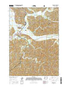
2017 Map of Reedsport
USGS Topo · Published 2017About this map
The confluence of the Umpqua River and Smith River dominates this coastal landscape, where the settlements of Reedsport and Gardiner developed as hubs for the regional timber and waterborne economies. In the north, the Siuslaw National Forest blankets the hills above Gardiner Reservoir, while the river is dotted with landforms such as Steamboat Island, Leeds Island, and Bolon Island. The mapping detail captures the complex drainage systems of Scholfield Creek and its many sloughs, including McIntosh Slough and Otter Slough. Local history is anchored by sites like the Gardiner Cem and the Jack Franz Bridge, while the industrial and residential grid of Reedsport contrasts with the more dispersed settlements at East Gardiner. This survey provides a modern view of the transport networks, from the heavy-duty W Railroad Ave to the remote logging roads like Nat For Dev Rd 41 winding through the ridges.
Find a feature on this map
74 named features on this map. Tap any name to fly to it.
Don’t see what you’re looking for? This feature index may not catch every label — zoom into the map to look around manually.
Map Details
Editions of this 2017 Reedsport Map
This is the sole edition of this map. No revisions or reprints were ever made.
Other maps of this area

1919 · Earl
USGS Topo · 1:48,000

1920 · Siltcoos Lake
USGS Topo · 1:62,500

1923 · Reedsport
USGS Topo · 1:62,500

1941 · Siltcoos Lake
USGS Topo · 1:62,500

1942 · Siltcoos Lake
USGS Topo · 1:62,500

1942 · Reedsport
USGS Topo · 1:62,500

1943 · Goodwin Peak
USGS Topo · 1:62,500

1954 · Coos Bay
USGS Topo · 1:250,000

1955 · Scottsburg
USGS Topo · 1:62,500
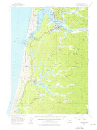
1956 · Reedsport
USGS Topo · 1:62,500