1942 Map of Reedsport
USGS Topo · Published 1942About this map
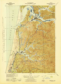
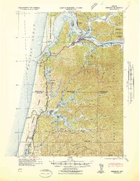
The Umpqua River estuary dominates this coastal landscape during the early years of World War II, showing the critical junction of water, rail, and road transit. In Reedsport, the Southern Pacific railroad crosses the river to reach Gardiner, while the Coast Highway provides the primary north-south artery. The presence of the Umpqua River LH and Umpqua Lighthouse State Park at the mouth of Winchester Bay underscores the area's importance for maritime navigation.
Find a feature on this map
58 named features on this map. Tap any name to fly to it.
Don’t see what you’re looking for? This feature index may not catch every label — zoom into the map to look around manually.
Map Details
Editions of this 1942 Reedsport Map
2 editions found
Other maps of this area

1896 · Coos Bay
USGS Topo · 1:125,000

1898 · Coos Bay
USGS Topo · 1:125,000

1900 · Coos Bay
USGS Topo · 1:125,000

1919 · Earl
USGS Topo · 1:48,000
1920 · Siltcoos Lake
USGS Topo · 1:62,500

1923 · Reedsport
USGS Topo · 1:62,500

1928 · Sitkum
USGS Topo · 1:125,000

1941 · Siltcoos Lake
USGS Topo · 1:62,500

1942 · Siltcoos Lake
USGS Topo · 1:62,500
1942 · Empire
USGS Topo · 1:62,500