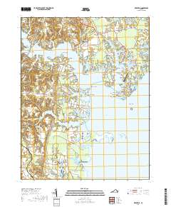
2019 Map of Reedville
USGS Topo · Published 2019About this map
Reedville stands at the center of this maritime landscape, where the Great Wicomico River meets the expansive Ingram Bay. The 2019 survey documents a region defined by its deep relationship with the Chesapeake, illustrated by the many necks of land like Cockrell Neck and Harveys Neck that reach into the surrounding waters. Small inland settlements such as Lilian and Beverlyville serve as connectors between the tidal creeks and the interior agricultural lands. Local history is anchored by sites like Shiloh Cem and Roseland Cem, while the modern recreational and conservation character of the peninsula is highlighted by the Potomac Heritage National Scenic Trail and the protected area of Dameron Marsh. The map provides a contemporary view of traditional Virginia coastal life, where the Reedville Airport and local docks support both industry and transit.
Find a feature on this map
173 named features on this map. Tap any name to fly to it.
Don’t see what you’re looking for? This feature index may not catch every label — zoom into the map to look around manually.
Map Details
Editions of this 2019 Reedville Map
This is the sole edition of this map. No revisions or reprints were ever made.
Other maps of this area

1916 · Kilmarnock
USGS Topo · 1:48,000

1917 · Heathsville
USGS Topo · 1:48,000

1917 · Kilmarnock
USGS Topo · 1:62,500

1917 · Ewell
USGS Topo · 1:62,500

1942 · Kilmarnock
USGS Topo · 1:62,500

1943 · Richmond
USGS Topo · 1:250,000
1944 · Sunnybank
USGS Topo · 1:31,680

1944 · Reedville
USGS Topo · 1:31,680
1944 · Heathsville
USGS Topo · 1:31,680
1949 · Irvington
USGS Topo · 1:24,000