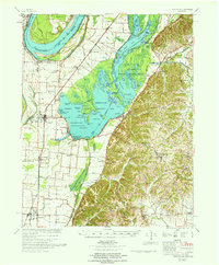
1967 Map of Reelfoot Lake
USGS Topo · Published 1967About this map
Reelfoot Lake and its intricate network of basins, pockets, and sloughs dominate this landscape along the Mississippi River in northwest Tennessee. The map illustrates a unique hydrologic environment where the Reelfoot National Wildlife Refuge and the Reelfoot State Wildlife Management Area preserve vast wetlands like Blue Basin and Swan Basin. Along the western shore, Tiptonville serves as a hub of activity near Reelfoot Airport, while the southern reaches show the Illinois Central railroad corridor passing through Ridgely and Wynnburg. The area's social history is evident in the numerous small congregations and burying grounds, including Crockett Chapel, Webb Chapel, and the Ridgely Cem. Detailed levee systems and revetments at Donaldson Point and Winchester Towhead reflect mid-century efforts by the Corps of Engineers to manage the powerful river flow that originally created this lake during the 1811-12 earthquakes.
Find a feature on this map
110 named features on this map. Tap any name to fly to it.
Don’t see what you’re looking for? This feature index may not catch every label — zoom into the map to look around manually.
Map Details
Editions of this 1967 Reelfoot Lake Map
This is the sole edition of this map. No revisions or reprints were ever made.
Other maps of this area

1925 · Reelfoot Lake
USGS Topo · 1:62,500

1939 · Reelfoot Lake
USGS Topo · 1:62,500

1939 · Portageville
USGS Topo · 1:62,500

1939 · Hickman
USGS Topo · 1:62,500

1939 · New Madrid
USGS Topo · 1:62,500

1939 · Bayouville
USGS Topo · 1:62,500

1939 · Dyersburg
USGS Topo · 1:62,500

1939 · Caruthersville
USGS Topo · 1:62,500

1950 · Obion
USGS Topo · 1:24,000

1951 · Obion
USGS Topo · 1:24,000