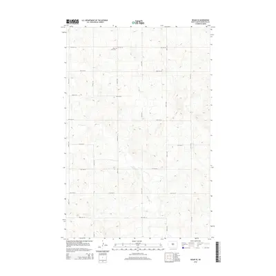
2014 Map of Regan SE
USGS Topo · Published 2014About this map
Ghylin Union Cem sits in the northern reaches of this Burleigh County landscape, providing a primary point of reference for genealogists tracing local families. The terrain is defined by the winding course of the W Br Apple Cr, which cuts through the prairie in the central and southern portions of the quadrangle. The map captures a section of North Dakota where the section-line grid is clearly established by a network of gravel and local roads, including 106th St NE and 279th Ave NE. The drainage patterns of the W Br Apple Cr and its unnamed tributaries illustrate the natural geography of the region before further modern development, preserved here in this 2014 survey. This map is particularly useful for identifying historical property boundaries and the relative positions of rural landmarks against the natural drainage of the Apple Creek watershed.
Find a feature on this map
16 named features on this map. Tap any name to fly to it.
Don’t see what you’re looking for? This feature index may not catch every label — zoom into the map to look around manually.
Map Details
Editions of this 2014 Regan SE Map
This is the sole edition of this map. No revisions or reprints were ever made.
Other maps of this area

1907 · Bismarck
USGS Topo · 1:125,000

1951 · Menoken
USGS Topo · 1:62,500

1951 · McKenzie
USGS Topo · 1:62,500

1954 · Bismarck
USGS Topo · 1:250,000

1954 · McClusky
USGS Topo · 1:250,000

1958 · Bismarck
USGS Topo · 1:250,000

1958 · McClusky
USGS Topo · 1:250,000
1975 · Solberg Butte
USGS Topo · 1:24,000
1975 · McKenzie NW
USGS Topo · 1:24,000
1975 · Keever Butte
USGS Topo · 1:24,000