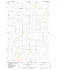
1975 Map of Regan SE
USGS Topo · Published 1977About this map
The West Branch Apple Creek winds through the rural landscape of Burleigh County in this mid-1970s survey, illustrating the agricultural and civic organization of the North Dakota prairie. The map details three primary townships: Ghylin, Ecklund, and Cromwell, showing the placement of the local Townhall and several deep wells essential for life in this environment. For genealogists, the Ghylin-Union Cem is a significant landmark, situated near the northern edge of the sheet. The terrain is further defined by scattered Gravel Pits, indicating local industrial activities alongside established section lines and property fences identified through photogrammetric methods. This documentation provides a clear view of the rural infrastructure before late-century shifts in land use.
Find a feature on this map
10 named features on this map. Tap any name to fly to it.
Don’t see what you’re looking for? This feature index may not catch every label — zoom into the map to look around manually.
Map Details
Editions of this 1975 Regan SE Map
This is the sole edition of this map. No revisions or reprints were ever made.
Other maps of this area

1907 · Bismarck
USGS Topo · 1:125,000

1951 · Menoken
USGS Topo · 1:62,500

1951 · McKenzie
USGS Topo · 1:62,500

1954 · Bismarck
USGS Topo · 1:250,000

1954 · McClusky
USGS Topo · 1:250,000

1958 · Bismarck
USGS Topo · 1:250,000

1958 · McClusky
USGS Topo · 1:250,000
1975 · Solberg Butte
USGS Topo · 1:24,000
1975 · McKenzie NW
USGS Topo · 1:24,000
1975 · Keever Butte
USGS Topo · 1:24,000