1915 Map of Regina
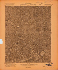
USGS Topo · Published 1915This historical map portrays the area of Regina in 1915, primarily covering Pike County as well as portions of Virginia. Featuring a scale of 1:48000, this map provides a highly detailed snapshot of the terrain, roads, buildings, counties, and historical landmarks in the Regina region at the time. Published in 1915, it is one of 2 known editions of this map due to revisions or reprints.
Find a feature on this map
41 named features on this map. Tap any name to fly to it.
Don’t see what you’re looking for? This feature index may not catch every label — zoom into the map to look around manually.
Map Details
Editions of this 1915 Regina Map
2 editions found
Historical Maps of Dry Fork Through Time
22 maps found

1914 Vergie
Pike County, KY

1915 Regina
Pike County, KY

1917 Regina
Pike County, KY

1954 Broad Bottom
Pike County, KY

1954 Dorton
Pike County, KY

1954 Hellier
Pike County, KY

1954 Jamboree
Pike County, KY

1954 Lick Creek
Pike County, KY

1954 Meta
Pike County, KY

1954 Millard
Pike County, KY

1954 Varney
Pike County, KY

1963 Jamboree
Pike County, KY

1978 Lick Creek
Pike County, KY

1978 Meta
Pike County, KY

1978 Millard
Pike County, KY

1979 Broad Bottom
Pike County, KY

1992 Broad Bottom
Pike County, KY

1992 Dorton
Pike County, KY

1992 Jenkins East
Pike County, KY

1992 Meta
Pike County, KY

1992 Varney
Pike County, KY

2001 Majestic
Pike County, KY