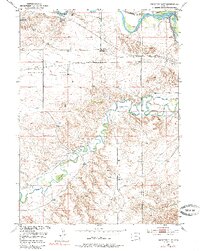
1950 Map of Register Cliff
USGS Topo · Published 1985About this map
The North Platte River and Laramie River converge in this high-plains landscape, serving as a vital corridor for westward expansion and modern irrigation. The map highlights the intersection of transportation and ranching history, documenting the site of the Register Cliff Monument and the Pony Express Sta near the Old Guernsey Ranch. These landmarks sit along the historic paths of the Bright and Southerland Trail, which cut across the wide expanse of Bettelyoun Flats.
Find a feature on this map
22 named features on this map. Tap any name to fly to it.
Don’t see what you’re looking for? This feature index may not catch every label — zoom into the map to look around manually.
Map Details
Editions of this 1950 Register Cliff Map
2 editions found
Other maps of this area

1896 · Hartville
USGS Topo · 1:125,000

1901 · Hartville
USGS Topo · 1:125,000

1950 · Rockeagle
USGS Topo · 1:24,000

1950 · Guernsey
USGS Topo · 1:24,000

1950 · Casebier Hill
USGS Topo · 1:24,000

1950 · Fort Laramie
USGS Topo · 1:24,000

1950 · Register Cliff
USGS Topo · 1:24,000

1950 · Guernsey Reservoir
USGS Topo · 1:24,000

1951 · Guernsey Reservoir
USGS Topo · 1:24,000

1951 · Antelope Gap
USGS Topo · 1:24,000