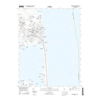
2014 Map of Rehoboth Beach
USGS Topo · Published 2014About this map
Rehoboth Beach and the neighboring coastal communities of Dewey Beach and Indian Beach occupy the narrow strip of land separating the Atlantic Ocean from the intricate waterways of Rehoboth Bay. The landscape is defined by its transition from oceanfront resorts to quiet marshland islands, including Big Reedy Island, Big Bacon Island, and Bush Island. The residential and commercial density of the Delmarva Peninsula is evident in the sprawling subdivisions of West Rehoboth, Shockley Heights, and Bald Eagle Village, which are connected by the prominent corridor of the Coastal Hwy.
Find a feature on this map
127 named features on this map. Tap any name to fly to it.
Don’t see what you’re looking for? This feature index may not catch every label — zoom into the map to look around manually.
Map Details
Editions of this 2014 Rehoboth Beach Map
This is the sole edition of this map. No revisions or reprints were ever made.
Other maps of this area

1888 · Cape May
USGS Topo · 1:62,500

1893 · Cape May
USGS Topo · 1:62,500

1898 · Cape May
USGS Topo · 1:62,500

1918 · Rehoboth
USGS Topo · 1:62,500

1918 · Cape Henlopen
USGS Topo · 1:62,500

1918 · Cape May
USGS Topo · 1:62,500

1925 · Cape May
USGS Topo · 1:62,500

1937 · Cape Henlopen
USGS Topo · 1:62,500

1938 · Rehoboth
USGS Topo · 1:62,500
1940 · Cape May
USGS Topo · 1:62,500