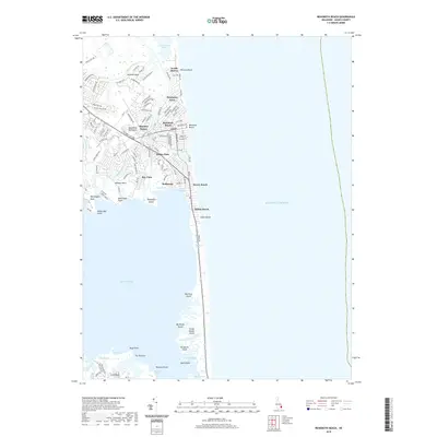
2019 Map of Rehoboth Beach
USGS Topo · Published 2019About this map
Rehoboth Beach and the Delmarva Peninsula shoreline define this coastal landscape where the Atlantic meets a complex network of bays and marshes. The area is characterized by dense residential developments such as Henlopen Acres, Shockley Manor, and Dewey Beach situated on narrow strips of land between the Atlantic Ocean and Rehoboth Bay. Historical drainage and water patterns are visible through features like Holland Glade, Bacon Island Creek, and Munchy Br. Moving south, the landscape shifts toward more tidal and marshy terrain, dotted with islands including Big Nose Island, Big Reedy Island, and Bush Island. This survey captures the intensive coastal development typical of the early 21st century, contrasted with the preserved natural areas surrounding Gordon Pond and Rehoboth Marsh.
Find a feature on this map
117 named features on this map. Tap any name to fly to it.
Don’t see what you’re looking for? This feature index may not catch every label — zoom into the map to look around manually.
Map Details
Editions of this 2019 Rehoboth Beach Map
This is the sole edition of this map. No revisions or reprints were ever made.
Other maps of this area

1888 · Cape May
USGS Topo · 1:62,500

1893 · Cape May
USGS Topo · 1:62,500

1898 · Cape May
USGS Topo · 1:62,500

1918 · Rehoboth
USGS Topo · 1:62,500

1918 · Cape Henlopen
USGS Topo · 1:62,500

1918 · Cape May
USGS Topo · 1:62,500

1925 · Cape May
USGS Topo · 1:62,500

1937 · Cape Henlopen
USGS Topo · 1:62,500

1938 · Rehoboth
USGS Topo · 1:62,500
1940 · Cape May
USGS Topo · 1:62,500