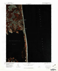
1980 Map of Rehoboth Beach
USGS Topo · Published 1982About this map
Rehoboth Beach and Dewey Beach are captured here during a period of significant coastal development along the Delaware shore. This 1980 color infrared orthophotogrammetric study highlights the density of the built environment against the delicate barrier ecosystem. The imagery clearly delineates the narrow strand of land separating the Atlantic Ocean from the expansive Rehoboth Bay, revealing the patterns of residential growth and the reach of the local canal and creek systems. To the north, the winding waters of the Glade and Holland flow through the interior wetlands, while to the south, the isolated Roman T Pond sits near the bay's edge. This specialized perspective provides researchers with a precise visual record of the shoreline and land use before subsequent decades of further expansion and environmental change.
Find a feature on this map
8 named features on this map. Tap any name to fly to it.
Don’t see what you’re looking for? This feature index may not catch every label — zoom into the map to look around manually.
Map Details
Editions of this 1980 Rehoboth Beach Map
This is the sole edition of this map. No revisions or reprints were ever made.
Other maps of this area

1888 · Cape May
USGS Topo · 1:62,500

1893 · Cape May
USGS Topo · 1:62,500

1898 · Cape May
USGS Topo · 1:62,500

1918 · Rehoboth
USGS Topo · 1:62,500

1918 · Cape Henlopen
USGS Topo · 1:62,500

1918 · Cape May
USGS Topo · 1:62,500

1925 · Cape May
USGS Topo · 1:62,500

1937 · Cape Henlopen
USGS Topo · 1:62,500

1938 · Rehoboth
USGS Topo · 1:62,500
1940 · Cape May
USGS Topo · 1:62,500