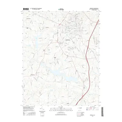
2016 Map of Reidsville
USGS Topo · Published 2016About this map
Reidsville serves as the central hub of this Rockingham County landscape, where urban streets transition into a network of reservoirs and rural communities. The town's expansion is bounded by several significant water bodies, including Lake Reidsville to the south and the smaller Clarks Lake and Washburns Lake nearer the center. To the west, Wentworth and Monroeton anchor smaller settlement clusters, while Sandy Cross and Norwood reflect the area's older residential patterns.
Find a feature on this map
194 named features on this map. Tap any name to fly to it.
Don’t see what you’re looking for? This feature index may not catch every label — zoom into the map to look around manually.
Map Details
Editions of this 2016 Reidsville Map
This is the sole edition of this map. No revisions or reprints were ever made.
Other maps of this area

1951 · Lake Brandt
USGS Topo · 1:24,000

1951 · Browns Summit
USGS Topo · 1:24,000

1953 · Greensboro
USGS Topo · 1:250,000

1954 · Greensboro
USGS Topo · 1:250,000

1962 · Greensboro
USGS Topo · 1:250,000

1966 · Greensboro
USGS Topo · 1:250,000

1970 · Ossipee
USGS Topo · 1:24,000
1971 · Southeast Eden
USGS Topo · 1:24,000
1971 · Ruffin
USGS Topo · 1:24,000
1971 · Bethany
USGS Topo · 1:24,000