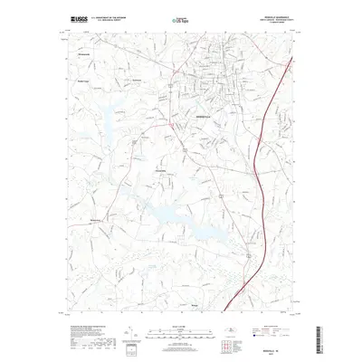
2019 Map of Reidsville
USGS Topo · Published 2019About this map
Reidsville stands as the primary urban center in this 2019 survey of Rockingham County, anchoring a landscape where small outlying communities like Wentworth, Monroeton, and Benaja define the rural periphery. The terrain is characterized by the complex drainage systems of the Haw River and several branches of Troublesome Creek, which feed into local water bodies such as Washburns Lake and Clarks Lake. These waterways have historically influenced the settlement patterns and road networks that connect family farms and early residential developments.
Find a feature on this map
202 named features on this map. Tap any name to fly to it.
Don’t see what you’re looking for? This feature index may not catch every label — zoom into the map to look around manually.
Map Details
Editions of this 2019 Reidsville Map
This is the sole edition of this map. No revisions or reprints were ever made.
Other maps of this area

1951 · Lake Brandt
USGS Topo · 1:24,000

1951 · Browns Summit
USGS Topo · 1:24,000

1953 · Greensboro
USGS Topo · 1:250,000

1954 · Greensboro
USGS Topo · 1:250,000

1962 · Greensboro
USGS Topo · 1:250,000

1966 · Greensboro
USGS Topo · 1:250,000

1970 · Ossipee
USGS Topo · 1:24,000
1971 · Southeast Eden
USGS Topo · 1:24,000
1971 · Ruffin
USGS Topo · 1:24,000
1971 · Bethany
USGS Topo · 1:24,000