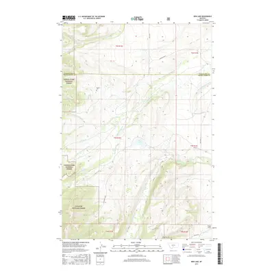
2017 Map of Rein Lake
USGS Topo · Published 2017About this map
Rein Lake and the surrounding high country of the Lewis & Clark National Forest and Gallatin National Forest define this landscape on the border of Wheatland and Sweet Grass counties. The terrain is deeply carved by drainage systems including Sweet Grass Creek and the American Fork, which are supported by man-made infrastructure like the Tronrud Ditch and the American Fork Ranch Ditch. These waterways underscore the ranching and irrigation history of the region. Local heritage is grounded at the Hopkins Cem near O'Hearn Cr, while the remote character of the area is mapped through a network of rural routes such as Big Elk Rd and Rein Ln. From the steep contours near Rough Gulch to the complex branching of Big Elk Cr, the map provides a clear view of the water rights and public land boundaries that shaped this part of Montana.
Find a feature on this map
34 named features on this map. Tap any name to fly to it.
Don’t see what you’re looking for? This feature index may not catch every label — zoom into the map to look around manually.
Map Details
Editions of this 2017 Rein Lake Map
This is the sole edition of this map. No revisions or reprints were ever made.
Other maps of this area

1886 · Little Belt Mts.
USGS Topo · 1:250,000

1894 · Little Belt Mts.
USGS Topo · 1:250,000

1897 · Little Belt Mts.
USGS Topo · 1:250,000

1898 · Little Belt Mts.
USGS Topo · 1:250,000

1902 · Little Belt Mts.
USGS Topo · 1:250,000

1948 · White Sulphur Springs
USGS Topo · 1:250,000

1958 · White Sulphur Springs
USGS Topo · 1:250,000

1961 · White Sulphur Springs
USGS Topo · 1:250,000

1965 · White Sulphur Springs
USGS Topo · 1:250,000
1972 · Lebo Lake
USGS Topo · 1:24,000