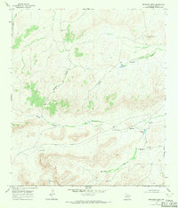
1968 Map of Reininger Draw
USGS Topo · Published 1971About this map
Reininger Draw and its network of ephemeral watercourses define this arid Pecos County landscape in the late 1960s. The topography is dominated by numerous draws and tanks that were essential for supporting ranching operations in this part of West Texas. Features like Nevins Windmills and the Reininger Tank Windmill reveal a dependence on groundwater extraction, while named landmarks such as the Roark Water Tank and Watermelon Water Tank highlight the importance of specific family-named infrastructure. The drainages, including Morales Draw and Nevins Draw, provide a clear picture of the natural water management patterns used by locals before modern development altered rural life. This survey captures the region's character as a managed grazing land where water security was the primary concern for survival and commerce.
Find a feature on this map
14 named features on this map. Tap any name to fly to it.
Don’t see what you’re looking for? This feature index may not catch every label — zoom into the map to look around manually.
Map Details
Editions of this 1968 Reininger Draw Map
This is the sole edition of this map. No revisions or reprints were ever made.
Other maps of this area

1920 · Longfellow
USGS Topo · 1:125,000

1923 · Sierra Madera
USGS Topo · 1:62,500

1928 · Comanche Spring
USGS Topo · 1:125,000

1954 · Fort Stockton
USGS Topo · 1:250,000

1958 · Fort Stockton
USGS Topo · 1:250,000

1968 · Cap Rock Butte
USGS Topo · 1:24,000

1968 · F C Ranch
USGS Topo · 1:24,000

1968 · Marathon Gap
USGS Topo · 1:24,000

1968 · Ebers Camp
USGS Topo · 1:24,000

1968 · Dimple Hills
USGS Topo · 1:24,000