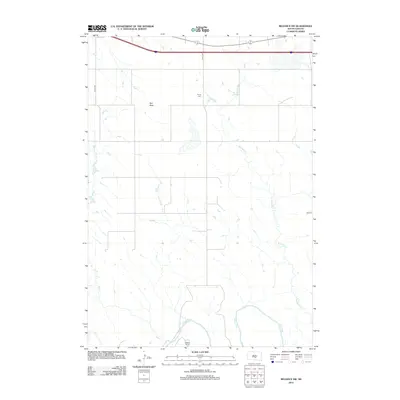
2012 Map of Reliance SW
USGS Topo · Published 2012About this map
Red Butte rises as a prominent landmark in this segment of Tripp County, overlooking a landscape defined by the winding course of the White River. The river forms the southern boundary of the quadrangle, where the Nelson Ranch sits near the water’s edge. This 2012 survey illustrates the sparse, rural nature of the region, where a network of section-line roads like 321st Ave and 324th Ave navigate the drainages of Bad Cr and Red Butte Cr. For local historians and genealogists, the Trinity Cem stands as a focal point of the area's early settlement history. The map captures the vast grazing lands and the precise relationship between the rolling terrain and the intermittent stream beds that carve through the prairie.
Find a feature on this map
9 named features on this map. Tap any name to fly to it.
Don’t see what you’re looking for? This feature index may not catch every label — zoom into the map to look around manually.
Map Details
Editions of this 2012 Reliance SW Map
This is the sole edition of this map. No revisions or reprints were ever made.
Other maps of this area

1951 · Ideal NE
USGS Topo · 1:24,000

1952 · Reliance SW
USGS Topo · 1:24,000

1952 · Reliance SE
USGS Topo · 1:24,000

1952 · Hamill NW
USGS Topo · 1:24,000

1952 · Hamill NE
USGS Topo · 1:24,000

1955 · Mitchell
USGS Topo · 1:250,000

1959 · Mitchell
USGS Topo · 1:250,000
1978 · Lyman
USGS Topo · 1:24,000
1978 · Kennebec SE
USGS Topo · 1:24,000
1978 · Reliance
USGS Topo · 1:24,000