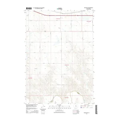
2015 Map of Reliance SW
USGS Topo · Published 2015About this map
Red Butte stands as a prominent landmark in this segment of south-central South Dakota, overlooking a landscape defined by the drainage systems of the White River and Red Butte Cr. The boundary between Lyman and Tripp counties cuts through the southern portion of the map, where the terrain drops toward the river valley. Evidence of early 21st-century rural infrastructure is visible in the section-line road grid, featuring thoroughfares such as Deer Valley Rd and Brule Rd. For those researching local heritage, the presence of Trinity Cem near the center of the map provides a specific point of interest within this sparsely populated ranching or farming region. Water features like Heap Lake and Bad Cr dot the northern sections, illustrating the hydrology of the plains before they reach the deeper breaks of the river to the south.
Find a feature on this map
29 named features on this map. Tap any name to fly to it.
Don’t see what you’re looking for? This feature index may not catch every label — zoom into the map to look around manually.
Map Details
Editions of this 2015 Reliance SW Map
This is the sole edition of this map. No revisions or reprints were ever made.
Other maps of this area

1951 · Ideal NE
USGS Topo · 1:24,000

1952 · Reliance SW
USGS Topo · 1:24,000

1952 · Reliance SE
USGS Topo · 1:24,000

1952 · Hamill NW
USGS Topo · 1:24,000

1952 · Hamill NE
USGS Topo · 1:24,000

1955 · Mitchell
USGS Topo · 1:250,000

1959 · Mitchell
USGS Topo · 1:250,000
1978 · Lyman
USGS Topo · 1:24,000
1978 · Kennebec SE
USGS Topo · 1:24,000
1978 · Reliance
USGS Topo · 1:24,000