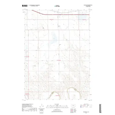
2017 Map of Reliance SW
USGS Topo · Published 2017About this map
Red Butte stands as a prominent topographical landmark in this rural landscape, overseeing a territory shaped by the winding courses of Bad Cr and Red Butte Cr. The southern border is defined by the White River, which carves through the boundary between Lyman and Tripp counties. This area reflects a quiet, dispersed settlement pattern typical of the South Dakota plains, where family-named routes like Schelske Rd and Deer Valley Rd connect isolated homesteads. The spiritual and social history of the community is anchored by the Trinity - Old Lutheran Cem and Huffnungs Cem, which serve as significant sites for genealogical research. Further inland, the presence of Heap Lake and numerous wetlands suggests a terrain that shifts between arid bluffs and vital water sources, supporting the agricultural life of the Lyman County countryside.
Find a feature on this map
26 named features on this map. Tap any name to fly to it.
Don’t see what you’re looking for? This feature index may not catch every label — zoom into the map to look around manually.
Map Details
Editions of this 2017 Reliance SW Map
This is the sole edition of this map. No revisions or reprints were ever made.
Other maps of this area

1951 · Ideal NE
USGS Topo · 1:24,000

1952 · Reliance SW
USGS Topo · 1:24,000

1952 · Reliance SE
USGS Topo · 1:24,000

1952 · Hamill NW
USGS Topo · 1:24,000

1952 · Hamill NE
USGS Topo · 1:24,000

1955 · Mitchell
USGS Topo · 1:250,000

1959 · Mitchell
USGS Topo · 1:250,000
1978 · Lyman
USGS Topo · 1:24,000
1978 · Kennebec SE
USGS Topo · 1:24,000
1978 · Reliance
USGS Topo · 1:24,000