
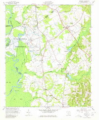
1953 Map of Rembert
USGS Topo · Published 1957About this map
Agricultural and institutional land use dominates this portion of the South Carolina Midlands during the early 1950s. The South Carolina Penitentiary and State Farm Number One occupy a large tract along the Wateree River, where the landscape is marked by silos, conveyors, and water infrastructure. Inland, the rural character is defined by a dense network of small communities and family-named landmarks. The topography transitions from the alluvial bottomlands of Gum Swamp and White Oak Slash Lake to the higher ground of the Sandhills, where settlements like Boykin, Hagood, and Rembert are connected by the Southern railroad line.
Find a feature on this map
47 named features on this map. Tap any name to fly to it.
Don’t see what you’re looking for? This feature index may not catch every label — zoom into the map to look around manually.
Map Details
Editions of this 1953 Rembert Map
2 editions found
Other maps of this area

1938 · Hagood
USGS Topo · 1:62,500

1941 · Spartanburg
USGS Topo · 1:250,000

1942 · Camden
USGS Topo · 1:125,000

1943 · Eastover
USGS Topo · 1:62,500

1946 · Sumter
USGS Topo · 1:62,500

1953 · Camden South
USGS Topo · 1:24,000

1953 · Eastover
USGS Topo · 1:24,000

1953 · Lugoff
USGS Topo · 1:24,000

1953 · Wedgefield
USGS Topo · 1:24,000
1953 · Leesburg
USGS Topo · 1:24,000