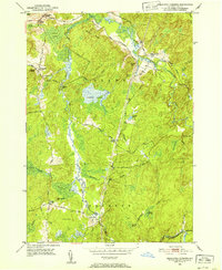
1951 Map of Remington Corners
USGS Topo · Published 1952About this map
Jerden Falls and several remote crossroads settlements anchor this mid-century survey of the Adirondack foothills along the Diana and Croghan town line. The landscape is defined by the winding course of the West Branch Oswegatchie River and its tributary, the Middle Branch Oswegatchie River, which historically supported local industry at sites like Kimball Mill and Bishas Mill. The area is characterized by a high concentration of named wetlands and ridges, including Sunday Swamp, Carley Swamp, and Brushy Ridge. Local travel in the 1950s relied on a network of narrow routes such as Pigtown Road and Hogsback Rd, connecting isolated homesteads at Tylers Corners and Dutton Corners. To the east, the terrain rises toward Panther Mtn, illustrating the transition from river-bottom swamps to the more prominent peaks of the northern forest.
Find a feature on this map
44 named features on this map. Tap any name to fly to it.
Don’t see what you’re looking for? This feature index may not catch every label — zoom into the map to look around manually.
Map Details
Editions of this 1951 Remington Corners Map
4 editions found
Other maps of this area

1911 · Lowville
USGS Topo · 1:62,500

1912 · Number Four
USGS Topo · 1:62,500

1913 · Lowville
USGS Topo · 1:62,500

1913 · Lake Bonaparte
USGS Topo · 1:62,500

1915 · Number Four
USGS Topo · 1:62,500

1916 · Lake Bonaparte
USGS Topo · 1:62,500

1916 · Oswegatchie
USGS Topo · 1:62,500

1918 · Oswegatchie
USGS Topo · 1:62,500

1948 · Ogdensburg
USGS Topo · 1:250,000

1950 · Utica
USGS Topo · 1:250,000