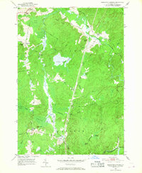
1951 Map of Remington Corners
USGS Topo · Published 1968About this map
The Middle Branch Oswegatchie River and its numerous tributaries define the landscape of Lewis County during this mid-century survey. The area is marked by a network of small, localized settlements typically established at crossroads, including Remington Corners, Tylers Corners, and Oswegatchie Corners. The topography is a complex patchwork of wetlands and low ridges, with Sunday Swamp, Carley Swamp, and Blue Swamp filling the lowlands between elevations like John Browns Mtn and Panther Mtn. The river's influence on local industry is evident at Kimball Mill and Bishas Mill, while the southern portion of the quadrangle shows the small community at Jerden Falls. An intriguing historical detail is the presence of the Erie Canal near the western boundary, cutting through the landscape alongside the natural flow of Oswegatchie Creek. This geography reflects a period where small-scale water power and rural connectivity were still central to the region's character.
Find a feature on this map
48 named features on this map. Tap any name to fly to it.
Don’t see what you’re looking for? This feature index may not catch every label — zoom into the map to look around manually.
Map Details
Editions of this 1951 Remington Corners Map
4 editions found
Other maps of this area

1911 · Lowville
USGS Topo · 1:62,500

1912 · Number Four
USGS Topo · 1:62,500

1913 · Lowville
USGS Topo · 1:62,500

1913 · Lake Bonaparte
USGS Topo · 1:62,500

1915 · Number Four
USGS Topo · 1:62,500

1916 · Lake Bonaparte
USGS Topo · 1:62,500

1916 · Oswegatchie
USGS Topo · 1:62,500

1918 · Oswegatchie
USGS Topo · 1:62,500

1948 · Ogdensburg
USGS Topo · 1:250,000

1950 · Utica
USGS Topo · 1:250,000