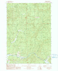
1990 Map of Remote
USGS Topo · Published 1990About this map
Middle Fork Coquille River carves a deep valley through the Coos County landscape, dictating the settlement patterns and transportation routes of this timbered region. The small community of Remote and nearby Enchanted Prairie cluster along the riverbanks, where the topography levels out into usable flats. These prairie pockets, including Plum Prairie and Long Prairie, offered rare open ground for agriculture and habitation amidst the steep, creek-cut ridges. Local history is anchored at the Enchanted Prairie Cemetery and Fetter Cem, while the presence of several Quarry sites indicates the area's extractive industry. A complex network of 4wd tracks and forest roads provides access to the high ground between numerous drainages such as Elk Creek, Bear Creek, and Tanner Creek, reflecting a landscape managed for resource extraction in the late twentieth century.
Find a feature on this map
29 named features on this map. Tap any name to fly to it.
Don’t see what you’re looking for? This feature index may not catch every label — zoom into the map to look around manually.
Map Details
Editions of this 1990 Remote Map
This is the sole edition of this map. No revisions or reprints were ever made.
Other maps of this area

1896 · Coos Bay
USGS Topo · 1:125,000

1898 · Coos Bay
USGS Topo · 1:125,000

1899 · Port Orford
USGS Topo · 1:125,000

1900 · Coos Bay
USGS Topo · 1:125,000

1903 · Port Orford
USGS Topo · 1:125,000

1928 · Sitkum
USGS Topo · 1:125,000

1942 · Coquille
USGS Topo · 1:62,500

1945 · Coquille
USGS Topo · 1:62,500

1954 · Coos Bay
USGS Topo · 1:250,000

1954 · Bone Mountain
USGS Topo · 1:62,500