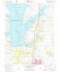
1975 Map of Rend Lake Dam
USGS Topo · Published 1977About this map
Rend Lake dominates this mid-1970s landscape, having transformed the northern reaches of the Big Muddy River valley into a sprawling reservoir for recreation and water management. To the south, the city of Benton serves as a hub of activity, featuring the County Fairground, Benton Municipal Airport, and several institutions like Lincoln Sch and Franklin Hospital. The map illustrates the region's industrial and agricultural character, noting the Old Ben No 24 Mine and scattered oil wells north of Steel City.
Find a feature on this map
68 named features on this map. Tap any name to fly to it.
Don’t see what you’re looking for? This feature index may not catch every label — zoom into the map to look around manually.
Map Details
Editions of this 1975 Rend Lake Dam Map
This is the sole edition of this map. No revisions or reprints were ever made.
Other maps of this area

1909 · West Frankfort
USGS Topo · 1:62,500

1910 · Herrin
USGS Topo · 1:62,500

1926 · Duquoin
USGS Topo · 1:62,500

1936 · Herrin
USGS Topo · 1:62,500

1939 · Ina
USGS Topo · 1:62,500

1941 · West Frankfort
USGS Topo · 1:62,500

1943 · Ina
USGS Topo · 1:62,500

1949 · Paducah
USGS Topo · 1:250,000

1950 · Paducah
USGS Topo · 1:250,000

1954 · Paducah
USGS Topo · 1:250,000