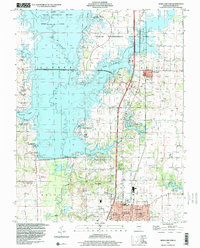
1998 Map of Rend Lake Dam
USGS Topo · Published 2000About this map
Rend Lake dominates this southern Illinois landscape, its expansive waters held by the Rend Lake Dam which transformed the Big Muddy River valley. The map documents a complex balance between massive public works and the older rural foundations of Franklin County. While large areas are dedicated to the Rend Lake State Wildlife Refuge and Wayne Fitzgerrell State Park, the land still bears the marks of its industrial and agrarian roots.
Find a feature on this map
62 named features on this map. Tap any name to fly to it.
Don’t see what you’re looking for? This feature index may not catch every label — zoom into the map to look around manually.
Map Details
Editions of this 1998 Rend Lake Dam Map
This is the sole edition of this map. No revisions or reprints were ever made.
Other maps of this area

1909 · West Frankfort
USGS Topo · 1:62,500

1910 · Herrin
USGS Topo · 1:62,500

1926 · Duquoin
USGS Topo · 1:62,500

1936 · Herrin
USGS Topo · 1:62,500

1939 · Ina
USGS Topo · 1:62,500

1941 · West Frankfort
USGS Topo · 1:62,500

1943 · Ina
USGS Topo · 1:62,500

1949 · Paducah
USGS Topo · 1:250,000

1950 · Paducah
USGS Topo · 1:250,000

1954 · Paducah
USGS Topo · 1:250,000