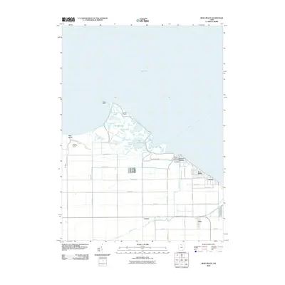
2010 Map of Reno Beach
USGS Topo · Published 2010About this map
Lake Erie defines the northern edge of this coastal landscape, where the marshy lowlands of the Cedar Point NWR and Maumee Bay State Park meet the residential lakefront. The transition from industrial waterway to recreational shoreline is evident in the alignment of Wards Canal near the community of Bono and the numerous inlets like Reno Side Cut that serve the local boating culture. Small clusters of cottages and homes are found at Niles Beach, Lakemont Landing, and Reno Beach, often built along a strictly gridded road system that contrasts with the irregular shapes of local ponds such as Lacourse Pond and Widgeon Pond. This environment is shaped by a complex drainage network, including the Sautter Ditch and Cedar Creek, which manage the water levels of these productive coastal wetlands.
Find a feature on this map
47 named features on this map. Tap any name to fly to it.
Don’t see what you’re looking for? This feature index may not catch every label — zoom into the map to look around manually.
Map Details
Editions of this 2010 Reno Beach Map
This is the sole edition of this map. No revisions or reprints were ever made.
Other maps of this area

1900 · Maumee Bay
USGS Topo · 1:62,500

1900 · Oak Harbor
USGS Topo · 1:62,500

1912 · Monroe
USGS Topo · 1:62,500

1914 · Monroe
USGS Topo · 1:62,500

1934 · Reno Beach
USGS Topo · 1:24,000

1934 · Point Place
USGS Topo · 1:24,000

1935 · Walbridge
USGS Topo · 1:24,000

1935 · Genoa
USGS Topo · 1:24,000
1936 · Erie
USGS Topo · 1:31,680

1938 · Walbridge
USGS Topo · 1:31,680