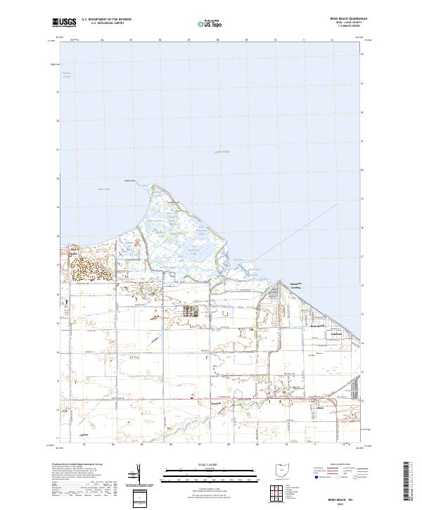
2023 Map of Reno Beach
USGS Topo · Published 2023About this map
Lake Erie defines the northern reaches of this coastal landscape, where the shoreline is a complex network of marshes, ponds, and residential enclaves. Significant wetland areas like Cedar Point Marsh and Mallard Club Marsh dominate the upper portion of the quadrangle, interspersed with specific ecological features such as Wolf Creek Pond and Carrington Pond. The drainage and water management systems required for this low-lying terrain are evident through features like Sautter Ditch, Wards Canal, and the Reno Side Cut.
Find a feature on this map
81 named features on this map. Tap any name to fly to it.
Don’t see what you’re looking for? This feature index may not catch every label — zoom into the map to look around manually.
Map Details
Editions of this 2023 Reno Beach Map
This is the sole edition of this map. No revisions or reprints were ever made.
Other maps of this area

1900 · Maumee Bay
USGS Topo · 1:62,500

1900 · Oak Harbor
USGS Topo · 1:62,500

1912 · Monroe
USGS Topo · 1:62,500

1914 · Monroe
USGS Topo · 1:62,500

1934 · Reno Beach
USGS Topo · 1:24,000

1934 · Point Place
USGS Topo · 1:24,000

1935 · Walbridge
USGS Topo · 1:24,000

1935 · Genoa
USGS Topo · 1:24,000
1936 · Erie
USGS Topo · 1:31,680

1938 · Walbridge
USGS Topo · 1:31,680