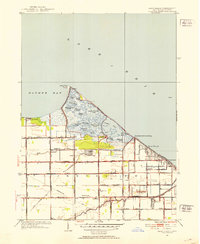
1952 Map of Reno Beach
USGS Topo · Published 1953About this map
Lake Erie and the intricate wetlands of Jerusalem Township define this coastal Ohio landscape, where marshy inlets and managed waterways shape the local geography. The shoreline is punctuated by a series of small waterfront settlements including Niles Beach, Lakemont Landing, Reno Beach, and Lakeland, many of which are situated alongside extensive pond systems like Wolf Creek Pond and Potters Pond. These areas are protected and managed via structures such as a Pumping Station and the Fish Hatchery, reflecting the area's historical reliance on water control and lake-based resources.
Find a feature on this map
57 named features on this map. Tap any name to fly to it.
Don’t see what you’re looking for? This feature index may not catch every label — zoom into the map to look around manually.
Map Details
Editions of this 1952 Reno Beach Map
This is the sole edition of this map. No revisions or reprints were ever made.
Other maps of this area

1900 · Maumee Bay
USGS Topo · 1:62,500

1900 · Oak Harbor
USGS Topo · 1:62,500

1912 · Monroe
USGS Topo · 1:62,500

1914 · Monroe
USGS Topo · 1:62,500

1934 · Reno Beach
USGS Topo · 1:24,000

1934 · Point Place
USGS Topo · 1:24,000

1935 · Walbridge
USGS Topo · 1:24,000

1935 · Genoa
USGS Topo · 1:24,000
1936 · Erie
USGS Topo · 1:31,680

1938 · Walbridge
USGS Topo · 1:31,680