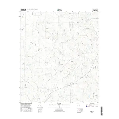
2017 Map of Reno
USGS Topo · Published 2017About this map
Nickleville and Reno anchor this rural landscape in Grady County, where a network of family and local roads such as Melton Brinson Rd and Old 179 S define the agricultural layout. The area is characterized by its numerous small burial grounds, including Magnolia Cem, Sasser Cem, and Tired Creek Cem, which serve as vital markers for local genealogical research. The terrain is drained by a complex system of waterways, with Sofkee Cr and Turkey Cr winding through the countryside alongside smaller tributaries like Merritt Br. This 2017 survey reflects the modern rural south, where small lakes like Gainey Lake and Harold Lake sit near long-established community centers like Bethel Cem and Saint Luke Cem. The map provides a clear view of the transition from wooded tracts to open fields in the Georgia coastal plain.
Find a feature on this map
88 named features on this map. Tap any name to fly to it.
Don’t see what you’re looking for? This feature index may not catch every label — zoom into the map to look around manually.
Map Details
Editions of this 2017 Reno Map
This is the sole edition of this map. No revisions or reprints were ever made.
Other maps of this area

1954 · Tallahassee
USGS Topo · 1:250,000

1955 · Whigham
USGS Topo · 1:62,500

1956 · Havana North
USGS Topo · 1:24,000

1956 · Cairo
USGS Topo · 1:62,500

1956 · Calvary
USGS Topo · 1:24,000

1957 · Beachton
USGS Topo · 1:24,000

1959 · Tallahassee
USGS Topo · 1:250,000

1960 · Tallahassee
USGS Topo · 1:250,000
1974 · Whigham
USGS Topo · 1:24,000
1974 · Climax North
USGS Topo · 1:24,000