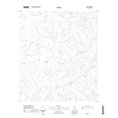
2020 Map of Reno
USGS Topo · Published 2020About this map
Nickleville and Reno anchor this rural landscape in Grady County, where a dense network of country roads connects a high concentration of family and community burial grounds. The map reveals the intricate topography of the Georgia coastal plain, carved by numerous waterways such as Turkey Cr, Sofkee Cr, and Maxwell Cr. These creek systems influence the local road patterns, with routes like Tired Creek Rd and Farmers Branch Rd winding through the terrain.
Find a feature on this map
89 named features on this map. Tap any name to fly to it.
Don’t see what you’re looking for? This feature index may not catch every label — zoom into the map to look around manually.
Map Details
Editions of this 2020 Reno Map
This is the sole edition of this map. No revisions or reprints were ever made.
Other maps of this area

1954 · Tallahassee
USGS Topo · 1:250,000

1955 · Whigham
USGS Topo · 1:62,500

1956 · Havana North
USGS Topo · 1:24,000

1956 · Cairo
USGS Topo · 1:62,500

1956 · Calvary
USGS Topo · 1:24,000

1957 · Beachton
USGS Topo · 1:24,000

1959 · Tallahassee
USGS Topo · 1:250,000

1960 · Tallahassee
USGS Topo · 1:250,000
1974 · Whigham
USGS Topo · 1:24,000
1974 · Climax North
USGS Topo · 1:24,000