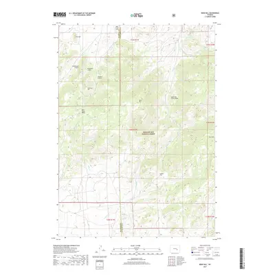
2017 Map of Reno Hill
USGS Topo · Published 2017About this map
Medicine Bow National Forest dominates this section of the Laramie Mountains along the Natrona and Converse County line. The landscape is defined by the high elevations of the Deer Creek Range, with Reno Hill and Pine Mtn serving as prominent landmarks. A complex network of drainages including Deer Creek, West Fork Soldier Creek, and Sawmill Creek has carved out numerous named features such as Moonshine Canyon and Sensebaugh Canyon. This high-country terrain shows little human development beyond Forest Service roads and the open area of Indian Flat. The presence of names like Six Horse Hill and Rainbow Canyon suggests the ranching and livestock history of this central Wyoming wilderness.
Find a feature on this map
32 named features on this map. Tap any name to fly to it.
Don’t see what you’re looking for? This feature index may not catch every label — zoom into the map to look around manually.
Map Details
Editions of this 2017 Reno Hill Map
This is the sole edition of this map. No revisions or reprints were ever made.
Other maps of this area

1954 · Torrington
USGS Topo · 1:250,000

1955 · Casper
USGS Topo · 1:250,000

1958 · Casper
USGS Topo · 1:250,000

1958 · Torrington
USGS Topo · 1:250,000

1959 · Squaw Spring
USGS Topo · 1:24,000

1959 · Bates Creek Reservoir
USGS Topo · 1:24,000

1960 · Ice Cave Mountain
USGS Topo · 1:24,000

1960 · Banner Mtn
USGS Topo · 1:24,000
1960 · Otter Creek
USGS Topo · 1:24,000

1960 · Reno Hill
USGS Topo · 1:24,000