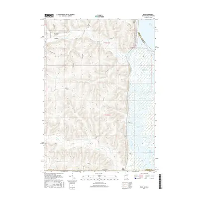
2016 Map of Reno
USGS Topo · Published 2016About this map
Minnesota Slough and a complex network of backwaters dominate the eastern edge of this borderland survey, where the river valley meets the high bluffs of the Driftless Area. The small settlement of Reno sits tucked beneath the steep elevation of Fairy Rock, while further west, Freeburg serves as a hub for the upland farming community. The landscape is defined by deep coulees carved by Crooked Cr, Clear Cr, and Winnebago Cr, each creating distinct valleys that dictate the placement of rural roads like Freeburg Ridge Rd and Nelson Valley Rd. Genealogists will find several well-documented burial sites including the Saint Nicholas Catholic Cem and the Winnebago Cem. Along the water, recreation and transport are evidenced by Millstone Lndg and the Reno Bottoms Canoe Trail, illustrating the contemporary use of the alluvial bottomlands near New Albin.
Find a feature on this map
57 named features on this map. Tap any name to fly to it.
Don’t see what you’re looking for? This feature index may not catch every label — zoom into the map to look around manually.
Map Details
Editions of this 2016 Reno Map
This is the sole edition of this map. No revisions or reprints were ever made.
Other maps of this area

1903 · Waukon
USGS Topo · 1:125,000

1926 · Stoddard
USGS Topo · 1:62,500

1929 · Ferryville
USGS Topo · 1:62,500

1932 · Ferryville
USGS Topo · 1:62,500

1956 · Brownsville
USGS Topo · 1:62,500

1958 · La Crosse
USGS Topo · 1:250,000

1961 · La Crosse
USGS Topo · 1:250,000

1965 · La Crosse
USGS Topo · 1:250,000
1965 · Stoddard
USGS Topo · 1:62,500

1966 · Ferryville
USGS Topo · 1:62,500