
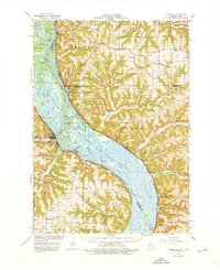
1966 Map of Ferryville
USGS Topo · Published 1968About this map
The Mississippi River dominates this mid-1960s landscape, serving as both a state boundary and a complex ecological corridor through the Upper Mississippi River Wild Life and Fish Refuge. The map reveals a heavily dissected terrain of high ridges and deep hollows, such as Victory Ridge and Cooley Ridge, which forced settlements and transportation routes into narrow corridors. Two major railroads, the Chicago Burlington and Quincy RR on the Wisconsin bank and the Chicago Milwaukee St Paul and Pacific RR on the Iowa side, flank the river's broad expanse of sloughs and islands like Battle Island and Island No 146. Inland, the survey preserves the locations of rural community centers including Red Mound Sch, Walnut Mound Cem, and the Immaculate Conception Ch, illustrating the persistent agricultural patterns of Crawford Co and Vernon Co before modern consolidation.
Find a feature on this map
83 named features on this map. Tap any name to fly to it.
Don’t see what you’re looking for? This feature index may not catch every label — zoom into the map to look around manually.
Map Details
Editions of this 1966 Ferryville Map
2 editions found
Other maps of this area

1903 · Waukon
USGS Topo · 1:125,000

1923 · Viroqua
USGS Topo · 1:62,500

1924 · Gays Mills
USGS Topo · 1:62,500

1926 · Gays Mills
USGS Topo · 1:62,500

1926 · Stoddard
USGS Topo · 1:62,500

1926 · Viroqua
USGS Topo · 1:62,500

1926 · Wauzeka
USGS Topo · 1:62,500

1929 · Ferryville
USGS Topo · 1:62,500

1929 · Prairie Du Chien
USGS Topo · 1:62,500

1932 · Ferryville
USGS Topo · 1:62,500