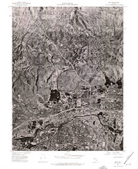
1974 Map of Reno
USGS Topo · Published 1976About this map
Reno and neighboring Sparks dominate this 1974 orthophoto quadrangle, revealing the rapid mid-seventies expansion of these high-desert urban centers. This unique photographic study captures the precise footprint of the growing suburbs and industrial zones before the massive development booms of later decades. The Truckee River snakes through the southern portion of the sheet, serving as the historical and geographic anchor for the region's layout. To the northwest, the residential enclave of Raleigh Heights sits positioned near the steep transition into the higher terrain that overlooks the valley. This map provides a clear look at the intersection of early interstate infrastructure and the natural riparian corridor, documenting how the built environment began to climb the surrounding slopes and fill the valley floor.
Find a feature on this map
4 named features on this map. Tap any name to fly to it.
Don’t see what you’re looking for? This feature index may not catch every label — zoom into the map to look around manually.
Map Details
Editions of this 1974 Reno Map
This is the sole edition of this map. No revisions or reprints were ever made.
Other maps of this area

1891 · Carson
USGS Topo · 1:125,000

1891 · Reno
USGS Topo · 1:125,000

1893 · Carson
USGS Topo · 1:125,000

1893 · Reno
USGS Topo · 1:125,000

1950 · Virginia City
USGS Topo · 1:62,500

1950 · Mt. Rose
USGS Topo · 1:62,500

1950 · Reno
USGS Topo · 1:62,500

1951 · Reno
USGS Topo · 1:62,500

1952 · Mt. Rose
USGS Topo · 1:62,500

1952 · Virginia City
USGS Topo · 1:62,500