
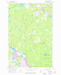
1955 Map of Republic
USGS Topo · Published 1957About this map
Iron mining operations define the landscape of Marquette County in the mid-1950s, centered around the industrial hubs of Republic and Humboldt. Near the southern end of the map, the Republic Mine is situated adjacent to the winding Michigamme River and the residential area of Park Hill. The presence of a Water Tank and Pump House near Lake Lory in the northeast underscores the infrastructure required for the Humboldt Mine and its nearby Mine Dump.
Find a feature on this map
43 named features on this map. Tap any name to fly to it.
Don’t see what you’re looking for? This feature index may not catch every label — zoom into the map to look around manually.
Map Details
Editions of this 1955 Republic Map
2 editions found
Other maps of this area

1899 · Witbeck
USGS Topo · 1:62,500

1955 · Champion
USGS Topo · 1:24,000

1955 · Witch Lake
USGS Topo · 1:24,000

1955 · Diorite
USGS Topo · 1:24,000

1955 · Witch Lake NE
USGS Topo · 1:24,000

1955 · Greenwood
USGS Topo · 1:24,000

1955 · Republic
USGS Topo · 1:62,500

1955 · Witch Lake
USGS Topo · 1:62,500

1955 · Republic SW
USGS Topo · 1:24,000

1955 · Champion
USGS Topo · 1:62,500