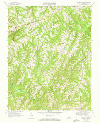
1968 Map of Republican Grove
USGS Topo · Published 1972About this map
The Banister River winds through the southern portion of this Halifax County landscape, where the terrain is defined by a dense network of dendritic stream valleys like Cow Creek and Childrey Creek. In the late 1960s, the area maintained a rural, decentralized settlement pattern centered around small hubs such as Republican Grove and Cody. This survey provides a precise record of local social infrastructure for genealogists, documenting numerous unnamed cemeteries and specific community landmarks including Clover Bottom Ch, Mulberry Ch, and the Sydnor Jennings Sch. The border between Pittsylvania and Halifax counties cuts through the western edge of the map, while the interior is marked by the path of a major pipeline and the local agricultural road network connecting quiet hamlets like Volens and Leda.
Find a feature on this map
35 named features on this map. Tap any name to fly to it.
Don’t see what you’re looking for? This feature index may not catch every label — zoom into the map to look around manually.
Map Details
Editions of this 1968 Republican Grove Map
3 editions found
Other maps of this area

1892 · Lynchburg
USGS Topo · 1:125,000

1892 · Appomattox
USGS Topo · 1:125,000

1947 · Roanoke
USGS Topo · 1:250,000

1953 · Greensboro
USGS Topo · 1:250,000

1954 · Greensboro
USGS Topo · 1:250,000

1954 · Halifax
USGS Topo · 1:62,500

1954 · Riceville
USGS Topo · 1:62,500

1956 · Brookneal
USGS Topo · 1:62,500

1956 · Gladys
USGS Topo · 1:62,500

1959 · Roanoke
USGS Topo · 1:250,000